 The World-Wide Web Virtual Library
[Alphabetical ||
Category Subtree ||
WWW VL database]
Tibetan Studies - Maps & Images of Tibet |
Edited by
Dr T. Matthew
Ciolek
[Est.: 7 Apr 1995. Last updated: 2 Nov 2008.]
The purpose of this document
is to provide central access point to online maps and graphics depicting Tibet and Tibetan culture.
The document is a part of the Asian
Studies WWW Virtual Library and of the Tibetan
Studies WWW Virtual Library. Please mail tmciolek@ciolek.com
if you know of relevant networked resource not in this page.
Conversely, please notify maintainers of this document if you
feel that any of the URLs listed on this page is no longer
good enough to be registered here. Your feed-back will be
gratefully appreciated.
|| Art, Theatre & Music [archival site]
|| Databases
|| Electronic Forums & E-mail Addresses
|| Flag
|| General Information
|| Human Rights
|| Language & Literature
|| Maps & Images
|| Medicine
|| Miscellaneous Materials
|| News & Electronic Newsletters
|| Politics
|| Religion
|| Sky Burial Ritual
|| Religious & Cultural Centers
|| Travel & Tourism
|| Tibet Online Bookstore
||
- The Tibetan National Flag [graphics & commentaries] (www.ciolek.com, Australia)
- Tibet in relation to the rest of the world [maps]
- Tibet and the surrounding regions [maps]
- Regions and Towns in Tibet [maps]
- Historical Maps of Tibet and Qinghai [maps]
- [Additional images of maps are available from Tibet Maps (images.google.com, US); also some useful references can be found in an archive of 1994 email exchanges in
Tibet Maps - FAQ (ANU, Australia)]
- Gazetteers, maps, and atlases of Tibet [maps]
- Images of Tibetan Countryside [photographs]
- Images of Tibetan People [photographs]
- Images of Eminent Tibetans [photographs]
- See also photographs in the section Guide to Tibetan Art (Ohio State U, US)
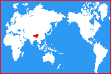
Tibet in relation to the rest of the world
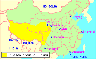
Tibet and the surrounding regions
- Tibet and the Neighbours
[6Kb GIF file. Copyright (c) 1995 andrew--at--dorje.demon.co.uk]
- Buddhism On The Silk Road
(International Dunhuang Project, The British Library, UK)
[Site contents: Buddhism in India and Central Asia; The Buddhism of the Kushana
Empire; The Buddhism of Khotan [incl. a map]; Chinese Buddhism on the Silk Road]
- Tibetan Buddhism on the Silk Road [incl. a map]; Other Followers of Buddhism (The Kucheans, The Sogdians, The Uighurs, The Tanguts);
[The site (est. Oct 2001), illustrated with detailed maps and timelines, aims at a general audience. It forms a part of the International Dunhuang Project (IDP) (idp.bl.uk). All images are from The British Library collection, or from the photographs of Aurel Stein.]
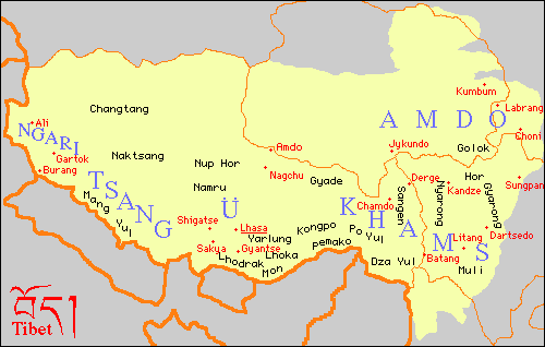
Regions and Towns in Tibet
Historical maps of Tibet and Qinghai
- Eastern Tibet borders ca. 750 CE. (Tibet Environmental Watch, US)
[Eastern extent of the Tibetan empire in the era of the Yarlung kings and the Tang Dynasty (ca. 7th - 9th c.)]
- Eastern Tibet borders ca. 1644 CE. (Tibet Environmental Watch, US)
[Eastern extent of the Tibetan empire from the Late Yarlung Period to the Beginnings
of Chinese Expansion into Eastern Tibet]
- Eastern Tibet borders ca. 1800 CE. (Tibet Environmental Watch, US)
[The Western Extent of the Manchu Empire during the Qing Dynasty (1644-1911)]
- Eastern Tibet borders ca. 1940 (Tibet Environmental Watch, US)
[Extension of China's administrative and political
hegemony along traditional trade routes from Amdo and Kham towards Central Tibet (1940-1950)]
- Chinese Administrative Regions: Eastern Tibet ca. 1996 (Tibet Environmental Watch, US)
[PRC's Administrative Control of Eastern Tibet]
- Missionary Map of Tibet (1897) (www.ciolek.com, Australia)
[245Kb GIF, Black & White file. The map
shows international boundaries, cities, settlements and major trade routes. Sourced from: Shaw, F. Becker. 1897. Missionary Map of Tibet (dotted lines indicate trade routes) / The Scandinavian Alliance Mission has also Tibetan Missionaries in Ghoom, India, in Baksadnar, Bhutan, and
in Guntak, Sikkim. In: "The Siege of Tibet," The Missionary Review of
the World, vol. X (n.s), February 1897, pp. 91-95 (The Map is printed
opposite p. 92)]
- A Map of Tibet
[63Kb GIF, Black & White file. Copyright (c) 1995 mvw--at--vwmaps.com]
- The historic map of Tibet prior to the Chinese invasion
[31Kb JPEG, Black & White file. Copyright (c) 1996 info--at--tibet.com
A Feb 1996 note by info--at--tibet.com: 'What the Chinese now call "Tibet", or Xizang in Chinese, refers
exclusively to the so-called "Tibet Autonomous region" founded in
1965, consisting of UTsang (Central and South Tibet) and small part of
Kham (south eastern Tibet). The major portion of Kham and
Amdo (north eastern Tibet) is incorporated into the Chinese provinces
of Sichuan, Gansu, Quinghaiand Yunnan. The term "Tibet" here will
mean the whole of Tibet including the regions of Amdo, Kham and
UTsang, that is, the Cholkasum in Tibetan'.]
- Map of Tibet
(and Qinghai) (Purdue U, US)
Four un-referenced, low-resolution maps: (1) Map of present Tibet, (2) Map of Tubo Dynasty;
(3) Map of Tibet in Yuan, Ming and Qing Dynasties, (4) Map of Tibetan
Distribution published online by the pro-PRC Tibet Study Association (formerly America-Tibet
Association), West Lafayette, IN, US.
[A note (8 Aug 1995) by: andrew (andrew--at--dorje.demon.co.uk)
Both maps (Map of present Tibet, Map of Tibetan Distribution) show the PRC territorial claim to the North East Frontier
Area NEFA - the border zone east of Bhutan and west of Burma. This
area is currently governed by India and was ceeded by Tibet to British
India under the Simla Convention in 1914. As negotiations were
conducted by the then Tibetan Govt. the Chinese have never recognised
this boundary. On all western maps the de-facto border is shown.
On the first map a boundary is shown called Old Provincial Boundary. This
was the Chinese claim under the undratified part of the Simla Agreement and
was also the de-facto border between 1912 when Chao Er Feng and his Qing
Army was forced from Lhasa after the 1910 expedition, and c1918 when the
same army was forced back east as far as Gandze.
On the second map the 'Tibetan distribution' stops at Derge which is
incorrect as can be seen by anyone who has been in the area roughly
west of Kanding. Also there is no shading in the Yellow River bend
area... an obvious error.
However, the maps appear to have been scanned in from old books and not
drawn with some particular aim in mind']
A note from Nov 2008:These maps appear to have been removed from the Net, and they do not have their copies
preserved at the Internet Archive (www. archive.org) and its Wayback Machine.
- Maps of Tibet (The Pitt Rivers Museum, Oxford, UK)
[Interactive maps of Central Tibet and Lhasa. * Maps of Tibet
(Where is Tibet?
Central Tibet - showing the photographers' travels,
Lhasa map - an overview from Dekyi Lingka to the Barkhor);
* Index of Tibetan Places
(By Region,
Alphabetically);
* Maps of Tibet photographed by Bell
(Map of Lhasa,
Map of Tibet,
Map of Tibet - with relief,
Darjeeling to Lhasa and Reting route);]
- Maps of Tibetan Trade Routes (OWTRAD Dromographic Digital Data Archives, www.ciolek.com, Australia)
[The collegion of digital charts includes:
tmcCNm0680a.html, tmcCNm0680b.html, tmcCNm0680c.html (Tibet, Sichuan and Yunnan, 680 CE-1950 CE, 'Tea and Horse' routes
tmcCNm1920.html (NW China,1920 CE, major roads and caravan routes)
tmcCNm1950.html, tmcCNm1950a.html (Tibet, 1900-1950 CE, trade and transportation routes)]
Gazetteers, maps, and atlases of Tibet
- THDL Gazetteer of Tibet and the Himalayas
(Tibetan & Himalayan Digital Library (THDL), U. of Virginia, US).
["The Gazetteer is designed to provide information about all varieties of places in Tibet and the Himalayas, in past and present times - nations, provinces, counties, monasteries, villages, mountains, natural regions and more.
The current 2.0 [i.e. Oct/Nov 2006 - ed.] release includes administrative units in contemporary China that have ethnic Tibetan populations, with detailed information only for the subunits of the Tibet Autonomous Region. We are now working on release 3.0 which will include details for all five provinces in China with Tibetan populations [i.e. TAR, Sichuan, Qinghai, Gansu and Yunan], and all politicial districts of Nepal as well. In the subsequent phase we will begin to incorporate our extensive data on Tibetan monasteries."]
- Tibetan Townships Database (Diamond Bay Research, US)
[Tibetan Placenames datasets have been produced
by the China Historical GIS
Project CHGIS for a digital gazetteer in cooperation with the
Tibetan and Himalayan Digital Library (U. of Virginia). The source
file is available from CHGIS upon request. Coverage: PRC prefectures
of Ali, Changdu (Chamdo), Lhasa, Linzhi Naqu, Rigaze (Shigaze), and
Shannan. In mid 2001 the database did not provide Tibetan names, nor
their long-lat coordinates.]
See also Asia Maps & GIS Web Resources (Harvard U., US)
- The Tibet Map Institute [also operating from www.tibetmap.org address] (www.tibetmap.com, France)
[The site, (not to be confused with the PRC-run travel site www.tibetmap.net) has as an objective the mapping of the Tibetan area using
(i) Toponyms given by travellers, cartographers, etc
(ii) Landsat satellite photos
The aim is to give a picture of Tibet before establishment
of the Chinese Administration.
Presently [March 2003] 80 maps (including more then 7000 place-names) are available from Ngari to Kham (between 28 to 33 degree north and 79 to 99 degree east). Each A3+ map covers 1 by 1 degree of long/lat. with a scale of 1:310 000 (33x45cm). Each A3 map covers 1 by 1 degree of long/lat. with a scale of 1:360 000 (30x42cm).
They are named 2788.5 in Chumbi valley.
2885 to 2898
2983 to 2998
3080 to 3098
3179 to 3198
3279 to 3298
Maps are available with different toponym characters: currents names, Wylie transliteration or Tibetan. Current names are in the Classical Tibet maps. A reduced map of central Tibet (scale=1,200,000) is also available.]
- Search Topographic Maps: Tibet (MicroGlobe LLC, US)
[Over 120 freely downloadable ex-Soviet military topographical maps in scales 1:1M, 1:500k, 1:200k. The site publishes Russian language maps in GIF format, including:
500k--i47-1 3.51 Mb 1:500 000 - Tibet, Ngoring Hu, Gyaring Hu, Donggi Cona
500k--i47-2 5.32 Mb 1:500 000 - Tibet, Tangnag, Zhongxin Zhan, Rabyog
500k--i47-3 5.32 Mb 1:500 000 - Tibet, Dainkog, Mainda, Beca
500k--i47-4 5.14 Mb 1:500 000 - Tibet, Huang He, Namda, Xia Zanggor
500k--i48-1 4.84 Mb 1:500 000 - Tibet, Lou-Chih, Ching-Shui-Kung, Tao-Chiang
500k--i48-3 5.25 Mb 1:500 000 - Tibet, Huang He, Huang-Chiao-Kuan, Yu-Pa-Tu
500k--j44-1 4.36 Mb 1:500 000 - Tibet, Kyrgyzstan, Wu-T-Ai, Xakur
500k--j44-2 4.74 Mb 1:500 000 - Tibet, Tongguzbasti
500k--j44-3 6.64 Mb 1:500 000 - Tibet, Karakoram, Ya-Erh-Ku-Shih-Miao, Yang-Ko-A-Li-Ko]
- A page of the web site by
US Embassy in Beijing
provides details of related printed publications:
- Qinghai Tibet Atlas
[Qinghai Xizang Gaoyuan Dituji], ed. By Chinese Academy of Sciences, Institute of
Geography. Published 1990 by Kexue Chubanshe [Science Publishing House].
This large format, 240
page atlas of Qinghai Province and the Tibetan Autonomous Region contains 140 pages including
full-color maps on the geography, topography, population distribution, residential density, nationalities
distribution, locations of Tibetan cities in various historical periods, political divisions, transportation,
locations of scientific stations, geology (including geological structure, earthquake history, warm spring
and volcano, satellite imagery, oil and natural gas), glaciers, solar irradiation distribution, temperature
map, climate map, river system, hydrology, soils, wetlands, grassland/vegetation, forests, rare birds,
crops, domestic animals, solar power and wind power, agricultural regions, and regional transportation
networks.
- Tibet Autonomous Region Atlas
[Xizang Zizhiqu Dituji], by the Tibet A.R. Survey Bureau, Beijing, July
1996, Zhongguo Ditu Chubanshe. Address: Baizhifang Xijie No. 3, Beijing 100054, CHINA.
Administrative boundarie correct as of March 1996.
This is a small format 170-page hardcover atlas. For
each county a one page essay introduces population, geography, climate, mineral resources, hydrology,
and road network.
- Place Names of The Tibetan Autonomous Region [Xizang Diming], ed. By Wu Zhenhua, published in
1995 by China Tibetan Studies Publishing House [Zhongguo Zangxue Chubanshe].
The book gives place names in
Tibetan and Chinese, together with postal codes and a Chinese
explanation of the origin of the name, down to the township and
village level, also including some passes, rivers, and other special
features. The book is 592 pages long, with about five entries per
page, and has an index.
- Maps of Lhasa and Tibet (Amnye Machen Institute, Dharamsala, India)
- Tibet and Adjacent Areas
Under Chinese Communist
Occupation
1:3,200,000
4,076 names of village, cities, monasteries, counties,
prefectures and provinces, lakes, rivers, roads
railways, airports and border crossing points, besides
other features are clearly indicated. The map clearly
reveals through colour codes how the Chinese
administration has divided this whole area into various
'ethnic' groupings namely Tibetan, Chang, Mongols,
Uighur, Tadjik, Kasak, Hui, Monggur (Hor) Salar,
Dongxiang, Bao'an, Yi (Lolo), Miao, Nashi (Jang), Lisu,
Bai, Pumi, Drung, Nu and Chinese. The outline of all
the Tibetan ethnic designated areas reveals a close
correspondence to the claims made by the Central
Tibetan Administration in Dharamshala.
ISBN 81-86227-16-4 "
- Map of Lhasa City 1:12,500
Over 590 names, located by grid and numbered
references, the map provides the correct names and
exact locations of all monuments, temples,
monasteries, schools, hospitals, hotels, shopping
centres, etc., and also the various offices of the
Chinese Communist occupation administration of the
'Tibet Autonomous Region' and Lhasa city. Also
included are military bases, offices and depots, and
Public Security and Armed Police offices and posts.
Prisons and labour camps are featured in detail. In
addition to road, street, lane and place names, all the
mountains surrounding Lhasa have been identified
and delineated with precise contour lines.
1995, Map 5 colours, Index (English and Tibetan) 64
pages, ISBN 81-86227-10-5
Maps of Lhasa
- Lhasa map (Tibet Heritage Fund, US)
[A series of three maps showing the state of the entire urban area of Lhasa in
1948, 1980 and 1998. These are reproduced below.
* A series of three map showing highlighting the number of pre-1948 buildings
existing in the old city of Lhasa in 1948, 1985 and 1998.
* A map showing The Lhasa Historic City Conservation Plan, showing 25
historic building earmkarked for preservation ]
Images of Tibetan Countryside
- Asian & Pacific Studies - Historical Photographs (RSPAS, ANU, Australia)
[* Digital Himalaya Project (Dept of Social Anthropology, U. of Cambridge, Cambridge, UK);
* Himalayan Art Resources (HAR); - Photographic Archives (Shelley & Donald Rubin Foundation, New York, NY, US);
* Historical Photos of Central Asia - Images of Life in Central Asia (Thomas Cole Antique Rugs and Textiles, San Francisco, CA, US);
* Photos of Tibet in the early 1940's (Art History, Skidmore College, Saratoga Springs, NY, US);
* Thomas H. Hahn Docu-Images - Tibetan lands and people (hahn.zenfolio.com, US);
* The Tibet Album: British Photography in Central Tibet 1920-1950 (The Pitt Rivers Museum, Oxford, UK);
* Vanished Kingdoms: The Wulsin Photographs of Tibet, China, and Mongolia, 1921-1925 (Burke Museum, U. of Washington, Seattle, US);
]
- Pictures from Tibet (www.iem.pw.edu.pl, Poland)
[1992 B&W photographs by NGFZH--at--livid.uib.no: Chinese Tanks in Lhasa, march 1989 *
Potala * Rongbuk Temple, 1990 * Rongbuk Temple * Tibetan Herd Camp * A
Village in Rongbuk Valley * The Yarlunzanho River * Picture from Lhasa
* Main Street of Lhasa * Mt. Everest]
- Jokang Temple (perso.wanadoo.fr, France)
[A colour photograph of the Jokang temple in Lhasa]
- Lhasa Archive Project (Tibet Heritage Fund, US)
[Documentary pictures from Lhasa: Alleyway in conservation area *
Children in alleyway * Conservation zone map * Doorway * Restored
house * Tramsikhang demolition * Windows]
- Pictures of Tibet and Qinghai (Purdue U, US)
[The resource provides ostensibly non-political, but de-facto
pro Chinese, information about Tibet. The pictures section contains
1980s and '90s annotated colour photographs of: Potala and Jokhang [7
pictures] * Lhasa city & Norbulingka [6 pictures] * Xigatse (Shigatse)
and surrounding areas (incl. Tashilhunpo, Xianu, Palchor temples,
Yumbu Lakhar palace, lake Yamdrok, Mt.Everest [8 pictures] * herdsmen
& villagers of Nagqu (Nachuka) and Northern Tibet [10 pictures] *
antelopes, wild asses and yaks in the Changtang National Reserve [5
pictures] * temples in Xining (Sining) & Qinghai [4 pictures]
- Tibet Photo Gallery Page (infonws0.kouku-k.ac.jp, Japan)
[Several un-unnotated, large, colour GIF files with
images of Potala, Lhasa, Samye, Gogkang Temple, Yangbajing]
- The Tibetan Frontier:
Journeys in The Himalaya and Tibetan Plateau (Indigo Gallery, Nepal)
[Photographs by Daniel Miller - Dancing With Yaks: People of Dolpo, Namdo Valley, Dolpo,
Nepal. 1978. Masked Dancer: Festival in Sakten, Eastern Bhutan. 1990.
Princess of the Pastoralists: Lady from Sakten, Eastern Bhutan. 1989.
Sacred Ground: Chortens near Dawu Village (Kham), Sichuan Province.
1996]
Images of Tibetan People
- Life in Tibet (The Chinese Univ of Hong Kong, HK)
[18 photographs (by the Photographic Society, New Asia
College) from the exhibits in the Virtual Gallery of The Chinese
University of Hong Kong]
- Monks and other folks (San Jose State U, US)
[1988 photographs: Potala Shrine with Photo of the Dalai Lama * Monks in front of Potala - Lhasa *
Tashilumpo Monks - Shigatse * Tibetan Man with Bell and Drum * Shaman Dancer -
Tashilumpo * Tibetan Women - Lhasa * Prayer - Gogkang Temple - Lhasa * Pilgrims
Prostrations - Gogkang Temple]
- Portrayals of Some Tibetan Women (www.grannyg.bc.ca, Canada)
[Photographs by Brian Harris: Nuns at Monastery Door * Pilgrim
Receiving Blessed Tea * Reciting Prayers in a Monastery Courtyard *
Two Nuns Laughing * Young Nomad Women]
- Photos of Tibet in the early 1940's (Skidmore College, US)
["These photos were taken in Tibet by members of the Tolstoy expedition of 1942-43. Two U.S. Army officers, Lt. Col. Ilya Tolstoy and Capt. Brooke Dolan were sent to Tibet from India to explore the possibility of getting military supplies to Chiang Kai-shek's Republican Chinese government, via Tibet."
Site contents:
Over 230 B&W PHOTOGRAPHS: * The Americans (The Expedition Scenes of Travel, Camping, Tolstoy and Dolan); * Tibetan Art (Painters and Carvers, Mural paintings, Sculpture, Chortens (stupas), Temples and other architecture, The Potala, Gyantse, Yemar, Textiles: Carpets and Cloth); * Tibetan Religion (The Ch'am/Masked Dance Festival, Monks and Monastic Life, The Regents Procession, The Potala, Gyantse, Other monastic sites, Pilgrims and Prostration); * Tibetan Society (Nomadic Pasturalists, Ordinary Tibetans, Pilgrims and Prostration, The Tibetan "Army", Urban Scenes, The Wealthy and Aristocrats); * The Chinese (The Chinese Army, On the Road to Gansu, Scenes of Western China); * Miscellany (A Postcard from Heinrich Harrer);
THE TOLSTOY-DOLAN EXPEDITION (Bibliography, Background Notes).
[A 1999 web site by Dr Rob Linrothe, Associate Professor and Director of Art History at Skidmore College. In addition to the Tibet Photographs site of he also published the following web pages: * Karsha's Chuchikjyal Temple, Zangskar, 1996 (http://www.skidmore.edu/academics/asianstudies/new2/linrothe/Karsha/Chuchikjyal.html); * Tibetan Art at Skidmore, 1998 (http://www.skidmore.edu/academics/asianstudies/new2/linrothe/TibetArtDisplay/Display.html); * Monks and monasteries in Amdo, 1998 (http://www.skidmore.edu/academics/asianstudies/new2/linrothe/Qinghai/TongrenSi.html); * Petroglyphs near Karsha, in Zangskar, 1998 (http://www.skidmore.edu/academics/asianstudies/new2/linrothe/Petroglyphs/RockArt.html); * QuickTime video of Ladakh and Mangyu chorten, 1994. (http://www.skidmore.edu/academics/asianstudies/new2/linrothe/Mangyu/Webpage.html) - ed.]
Images of Eminent Tibetans
- His Holiness The 14th Dalai Lama (Carleton U, Canada)
[Cover "A Flash of Lightning in the Dark of Night". Photo by Raphaelle
Demandre (85 Kb Colour)]
- His Holiness The 14th Dalai Lama (Carleton U, Canada)
[81 Kb GIF. B & W photo by Alison Wright. Published by Snow Lion Publications]
- His Holiness The 14th Dalai Lama (www.bekkoame.or.jp,Japan)
[29 Kb GIF. Colour photo (July/24th/1994 Jispa,India) by Takao Miyatani (miyatani--at--can.bekkoame.or.jp)]
- Tibetan Religious Teachers (www.dzogchen.org,US)
[B & W photographs & short biographical notes of: HH the XIV Dalai
Lama * HH Gyalwa Karmapa XVI * HH Karmapa XVII * HH Dudjom Rinpoche *
Dilgo Khyentse Rinpoche * Nyoshul Khenpo Rinpoche * Kalu Rinpoche *
Tulku Pema Wangyal Rinpoche, Tulku Urgyen Rinpoche, Dilgo Khyentse
Rinpoche, Shechen Rabjam Rinpoche & Chokyi Nyima Rinpoche * Kalu
Rinpoche with the Superimposed image of his Reincarnation, Yangsay
Rinpoche * Jatral Rinpoche * Tulku Urgyen Rinpoche]
Additional image files with Tibet-related materials and maps, links to such
resources, corrections and comments will be appreciated. Please contact: tmciolek@ciolek.com
Updates, additions and corrections to this page have been kindly provided by:
andrew--at--dorje.demon.co.uk,
Merrick Lex Berman,
Jim Casilio.
C. Davis,
J. Fletcher,
J. Johnson,
J. Lebow,
Hanno Lecher,
Pamela Logan,
D. Martin,
C. Meehan,
Stephen Mikesell,
D. Miller,
T. Miyatani,
S. Tenzin,
Dr Susan Whitfield,
M. Winkler,
Martin von Wyss.
Back to Tibetan Studies WWW VL top page

visitors to www.ciolek.com since 08 May 1997.
Maintainer: Dr T. Matthew Ciolek (tmciolek@ciolek.com)
Copyright © 1995-present by T. Matthew Ciolek. This Web page may be linked to any
other Web pages. Contents may not be altered.
URL http://www.ciolek.com/WWWVLPages/TibPages/tib-maps.html
[See also:
Aboriginal Studies ||
Asia Search Engines ||
Buddhist Studies ||
Ciolek - Research Papers ||
Global Timeline ||
|| Information Quality ||
Tibetan Studies ||
Trade Routes ||
Zen Buddhism
]