REFERENCE TOOLS
Most of the searches require Netscape v.4 or higher[A catalogue, study, maps and bibliography of the 11th-13th c. caravanserais (khans, hans) in Turkey]
[Online edition of a gazetteer of places associated with the Roman world, compiled by Dr. J. G. Th. Graesse. 1909. Orbis Latinus. Berlin: Richard Carl Schmidt & Co.]
[The Location of Roman Legions from Caesar to ca. 300 AD (sections: Britannia, Germania, Danuvius, Syria, Africa, Hispania); The Tabula Peutingeriana, the only surving copy of a Roman road map showing the roads and distances across the Roman Empire (*Overview from West to East, *Section 1 - Spain, *Section 2 - Lugdunum, *Section 3 - Colonia, Treveri, Argentorate, *Section 4 - Mediolanum, *Section 5 - Aquilea, Regina, Lauriacum, *Section 6 - Roma, *Section 7 - Belgrade, *Section 8 - Patras, *Section 9 - Athens, *Section 10 Constantinopolis, *Section 11 Kajseri, Trabzon, *Section 12 - Antiochia, *Section 13 - Urfa, *Section 14 - further East)]
[Alphabetical List of All Entries; List by Roman Provinces; List by French Departments; List by Entry Type; Stops Along Ancient Itinerary Routes]
[Index to volumes 1-75 (1927-2001)]
['mapping the ancient world, from Athens to Zucchabar', U. of North Carolina, USA.]
[work on ' a standardized coding system to identify historical administrative units for different periods in Chinese History. ' Provides links to Chinese placenames search engines]
[an atlas depicting in 21 maps the states of Europe at the end ef each century from AD 1 to AD 2000]
[Atlas historique de l'Antiquite tardive, Medieval Maps, Maps of Great Britain , Historical Maps of Europe , Maps Relating to Islam's Historical Development, .... Slovakia: Historical Maps, Historic Cities: Maps and Documents, Khazarian Historic Maps, Uni Maps]
[Presentacion; Novedades; Estatutos; Congresos; Proyectos; Enlaces; Actividades Complementarias]
[Digitized historical sources (The Han Histories 206 BCE - 220 CE; Faxian [Fa-Hsien] 399-414; Francesco Balducci Pegolotti's Merchant Handbook 14th C.; The Tarikh-i-Rashidi by Mirza Muhammad Haidar 1546-47; Memoirs of Babur early 16th c.; Anthony Jenkinson 1557-60; Richard Steel & John Crowther 1615-16; Journey of Benedict Goës early 17th c.; Adam Olearius 1633-39; Jean Chardin 1660s-70s) dealing with the Silk Road', Silk Road Seattle Project, USA.]
[88KB document, edited (since 1995) by Frank Tapson, Centre for Innovation in Mathematics Teaching, U. of Exeter, UK]
[edited (since 1999) by Russ Rowlett, Center for Mathematics and Science Education, U. of North Carolina, USA.]
[71KB document, by Reade Advanced Materials, Providence, RI, USA. Useful for the calculation of the weight of cargo, or inversely, the required cargo space. Listed materials include timber, metals, minerals, foodstuffs].
[Energy expenditure (in calories) per body weight (in lb and kg), length of time and 158 sport, occupational and outdoor activities. The calculator is based on the Compendium of Physical Activity. ACSM's Resource Manual for Guidelines for Exercise Testing and Prescription, 3rd ed. (Williams and Wilkins, 1998). ].
[Numeric codes to identify imports/exports: Live animals; Animal products; Vegetable products; Animal or vegetable fats, oils and waxes; Prepared foodstuffs, beverages; Mineral products; Products of the chemical industries; Plastics, rubber; Raw hides and skins, leather, furskins; Wood and articles of wood, cork; straw, wicker; Textile and textile articles; Footwear, headgear; Articles of stone, plaster, cement, clay and glass; Precious or semi-precious stones and metals; Base metals and articles of base metal; Machinery and mechanical appliances; Vehicles, aircraft, vessels; Instruments and apparata; Arms and ammunition; Miscellaneous manufactured articles; Works of art, collectors' pieces and antiques; Intermediate chemicals for dyes].
[The Transportation Research Thesaurus (TRT) is a tool to improve the indexing and retrieval of transportation information. The thesaurus covers all modes and aspects of transportation. The TRT's purpose is to provide a common and consistent language between producers and users of transportation information.]
Introduction
- Trade routes and urban supply routes are the sequences of pathways and stopping places used for the commercial transport of cargo. Trade routes connect public markets. They also link producers with such markets. Supply routes, by contrast, take products directly to individual consumers. When such activities are secret, so as to avoid paying custom duties, or to avoid detection by authorities, a smuggling route is created. The geographical scale of such operations varies very strongly. Accordingly, trade routes are best conceptualised as long-distance arteries, ones which span tens or hundreds of kilometres, and which are routinely connected to countless smaller capillaries of both commercial and non-commercial transport.
- In addition to trade/supply routes, there are also many other networks which move (a) goods, (b) people and (c) information:
- administrative routes (used for periodical inspections, administration of justice, and revenue collection)
- exchange routes (used for establishment and maintenance of good social relationships between neighbouring communities)
- military routes (ones which supply fortresses and garrisons, routes of advance, and 'communication lines' established during military campaigns)
- nomadic transhumance routes
- passenger routes (established by movement of fare-paying travellers)
- pilgrimage routes
- pillagers' raiding routes
- postal routes (operated by runners, riders, and couriers travelling by carts and ships)
- settlers' migration routes
- signals routes (maintained by means of homing pigeons, beacons, watch-towers, and semaphore stations)
- tribute routes (used as an instrument of international politics)
- The comparative study of organisation, history, geography and logistics of local, regional and global trade routes, and other movement, transportation, and communication networks is called dromography (Gr. 'dromos' [way, street, route, corridor] + Gr.'graphos' [to write]) [The term 'dromography' was coined by T. M. Ciolek, in April 2001]
- The dilemmas and pitfalls of direct digital mapping [notes are to be provided]
- Steps towards creation of researcher-friendly, interoperable data sets [notes are to be provided]
- Stages in production of an electronic thematic atlas [notes are to be provided]
Return to top
 Cumulative contents of data sets georeferenced and published at this site so far.
|
OWTRAD GIS-ready Downloadable Data Sets
- OWTRAD Dromographic Digital Data Archives (ODDDA)
[Be sure to check back frequently for updates and new data sets. These files are now published in CSV, MapInfo and Google Earth (KML) formats]
Return to top
OWTRAD Gazetteers and Catalogues
- The OWTRAD Gazetteer: Introduction
[Includes a list of online Lat/Long Gazetteers] - The OWTRAD Gazetteer: Georeferenced Nodes
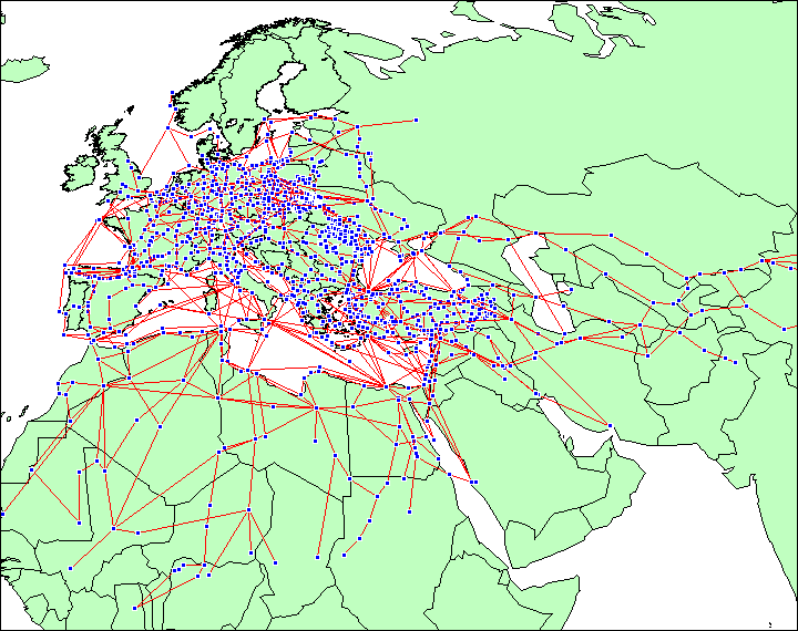
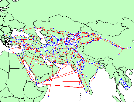
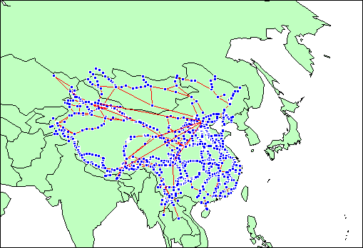
[Coordinates and other details of 12,500 variant names for 3,130 unique places in Eurasia and Africa] - A Catalogue of Georeferenced Caravanserais/Khans
[Details of 756 caravanserais/khans, funduks, and other rest houses supporting long-distance communication routes] - A Catalogue of Georeferenced Travel/Trade Structures
[Details of 328 bedestans/qaysariyyas, bridges, forts, lighthouses/beacons, markets/bazaars, wells/sardobas, etc. supporting long-distance communication routes]
Return to top
Trade Routes Online Resources
- See the Trade Routes Resources Blog
- See also (and copy to your site) the RSS feed

Trade-Routes[use"@"]mm.isu.edu scholarly forum
(Historical Transport/Communication/Pilgrimage Networks forum)-
This mailing list provides a world-wide electronic forum
for exchange of scholarly and factual information on the
history, geography, anthropology and logistics of traditional
communication, movement, and transportation networks of the world.
The list was established on 30 April 2000 by the Old World
Trade Routes (OWTRAD) Project (www.ciolek.com/owtrad.html).
The list has a special focus on research and construction of accurate,
correctable and interoperable geo/chrono-referenced electronic
data-sets describing known land, river and maritime trade and pilgrimage routes
of Eurasia and Africa between 10,000 BCE and approx. 1820 CE (i.e. from
the end of the Ice Age till the revolution in transport caused by the steam-engine technology). However, other foci,
as well as other geographical and historical contexts are also given
due attention.
To join the forum use the registration page (http://mm.isu.edu/mailman/listinfo/trade-routes)
or use the box below:
To reach the human beings that manage this mailing list (i.e. Prof. J. B. Owens, Idaho State University and Dr T. M. Ciolek, The Australian National University) please send your message
to: trade-routes-admin[use"@"]mm.isu.edu [In Oct 2008 the mailing list had over 220 subscribers.]
Return to top
The OWTRAD Research Rules
[notes are to be provided]- Research rules: introduction
- Transcription process: basic steps
- Transcription rules and commentaries
The OWTRAD Notation System
Standard procedures for systematically extracting from historical and contemporary sources geo-referenceable information about traditional trade, transportation, movement, and communication routes.Return to top
Useful Bibliographies
- OWTRAD Sources and Bibliography
[Bibliographical details of publications cited in OWTRAD documents]Other Bibliographies
- Online Bibliography of Geographical Publications
[The American Geographical Society Collection, University of Wisconsin-Milwaukee, USA] - International Bibliography of the Discoveries and Overseas Encounters (Universidade de Coimbra, Portugal)
[An analytical bibliography by Alfredo Pinheiro Marques, published in Portuguese and English. The online bibliography focussed on Portuguese and European Overseas Expansion (from the 13th- to the 18th-century) and the History of the Geographical Discoveries in general and their Technical and Scientific Achievements in particular, is regularly updated and permanently accessible.] - Dutch Portuguese Colonial History
(www.colonialvoyage.com, Italy)
[Dutch-Portuguese colonial history in Arabia Gulf, India, Sri Lanka, Malaysia, Brazil, Taiwan, Ghana, Macao, Timor. It publishes photographs of colonial remains of forts and heritage; and maps. Updated intensively. The site provides annotated Bibliographies.]
Return to top
Trade, Communication and Pilgrimage Routes' Terminology
- Trade Routes Glossary [English and foreign language terms dealing with concepts, units of measurements, architectural structures, and logistical arrangements related to long-distance trade, communication, and pilgrimage routes]
Return to top
Trade Routes: International Terminology
- Basic Terms:
EN: nodes, places, roads, trails, routes, sea-route;
ES: nodos, lugares, caminos, rastros, rutas;
FR: noeuds, endroits, chemines, trainees, itineraires;
DE: Knotenpunkte, Plaetze, Strassen, Spuren, Wege, Seeweg; - Concepts:
EN: trade routes, pilgrimage routes, invasion routes, movement corridors, transportation networks;
ES: rutas del comercio, rutas del peregrinaje, rutas de la invasion, pasillos del movimiento, redes del transporte;
FR: itineraires du commerce, itineraires de pelerinage, itineraires d'invasion, couloirs de mouvement, reseaux de transport;
DE: Handelstrasse, Pilgrimagewege, Invasionwege, Bewegungsflure, Transportnetze; - Expressions:
EN: Silk Road; Spice Route; Amber Route; Salt Route, Tin Route,
ES: Camino de Seda; Ruta de la Especia; Ruta de la Ambarino; Ruta de la Sal;
FR: Route en Soie; Itineraire d'Epice; Itineraire d'Ambre; Route du Sel
DE: Seidenstrasse/Seidenroute; Gewuerzstrasse/Gewuerzroute; Bernsteinstrasse; Saltzstrasse;
Return to top
Appendices
- Ciolek, T.M. 2000. Digitising Data
on Eurasian Trade Routes: An Experimental Notation System
www.ciolek.com/PAPERS/pnc-berkeley-02.html - Ciolek, T.M. 2000. Global Communication: a Timeline
www.ciolek.com/PAPERS/milestones.html - GORDON Stewart, T. Matthew Ciolek & Lizbeth H. Piel. [Work in progress, 2009-present]. Mapping Buddhist Monasteries 200-1200 CE Project
monastic-asia.wikidot.com
Return to top
