www.ciolek.com >
old world trade routes (owtrad) >
owtrad dromographic digital data archives (oddda) >
tmcKHm1200.html
Suggested citation format:
Ciolek, T. Matthew. 2002. Georeferenced data set (Series 1 - Routes): Roads in Cambodia [Khmer] 1200-1300 CE.
OWTRAD Dromographic Digital Data Archives (ODDDA). Old World Trade Routes (OWTRAD) Project.
Canberra: www.ciolek.com - Asia Pacific Research Online.
www.ciolek.com/OWTRAD/DATA/tmcKHm1200.html
Old World Trade Routes (OWTRAD):
Roads in Cambodia [Khmer] 1200-1300 CE.
Dr T. Matthew Ciolek,
Research School of Pacific and Asian Studies,
Australian National University,
Canberra ACT 0200,
Australia
tmciolek@ciolek.com
http://www.ciolek.com/PEOPLE/ciolek-tm.html
Data set created: 19 Jul 2002. Last updated: 27 Apr 2008
Contents of this data set
This document comprises a georeferenced data set
belonging to the Old World Trade Routes (OWTRAD) project. It can be used for historical research (e.g. validation of some set of facts); analyses of distances/ travel times/ modes of travel/ cargo moved along particular transportation corridors; construction of an electronic map, or GIS model of the movement/ transport/ communication circuits in a given area and time-period.
The data originate in the studied analogue source(s) (indicated below). Here they are disambiguated, subjected to georeferencing, and re-stated in a highly standardised manner. Consequently, OWTRAD data are easier to crossreference, share, analyse and manipulate. Also, they are more precise, and easier to test and correct than the original sources.
Although careful judgement has been applied in constructing this body of electronic data, it is still possible that some oversights or errors may be lurking in it still. Therefore, please treat OWTRAD data as sets of plausible hypotheses, i.e. bodies of statements which always are in need of further refinement, and further testing. Whenever necessary, do test and cross-validate OWTRAD routes/tracks (and their nodes) against each other, as well as against books, maps and georeferenced data sets published by other researchers, or agencies. Please be mindful of discrepancies or contradictions (and their likely sources) between these various bodies of information. Also, whenever possible, please test all such georeferenced materials against the detailed primary historical/ geographical/ anthropological/ logistical information about the region/time-period in question.
To keep OWTRAD data a source of dependable research information, please email tmciolek@ciolek.com with any corrections, addenda, or comments. Your input, dear reader, is always warmly welcome and highly appreciated.
Metadata [DublinCore] describing this data set
| dc.title |
Roads in Cambodia [Khmer] 1200-1300 CE. |
| dc.creator.PersonalName |
T. Matthew Ciolek |
| dc.creator.PersonalName.Address |
RSPAS, The Australian National University, Canberra, Australia [tmciolek@ciolek.com] |
| dc.subject |
trade routes |
| dc.subject |
methodology |
| dc.subject |
historical data |
| dc.subject |
historical maps |
| dc.subject |
cultural databases |
| dc.description |
36 data points defining various roads and
movement corridors in SouthEast Asia |
| dc.publisher |
www.ciolek.com |
| dc.publisher.address |
Canberra, Australia |
| dc.date |
2002-07-19 |
| dc.type |
Data set |
| dc.format |
WWW pages - static |
| dc.identifier |
http://www.ciolek.com/OWTRAD/DATA/tmcKHm1200.html |
| dc.relation.type |
IsBasedOn |
| dc.relation.identifier |
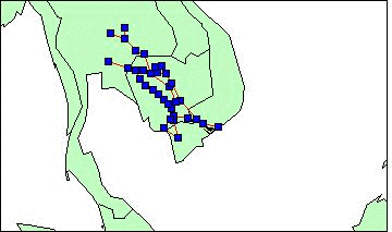
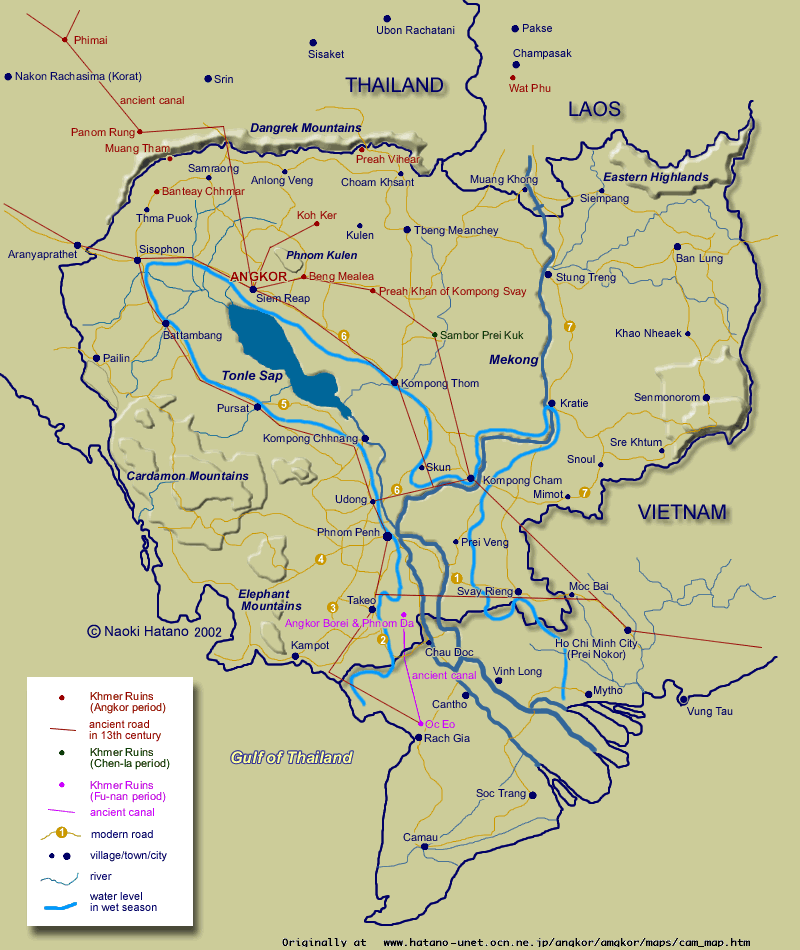
HATANO, Naoki. 2002. [An unnamed map of ancient Khmer] (v. Jul 2002).
www.hatano-unet.ocn.ne.jp/angkor/angkor/maps/cam_map.htm
a copy of Hatano's original map is available at
http://www.angkor-ruins.com/maps/maps.htm and at
http://www.ciolek.com/OWTRAD/DATA/images/extra-images/hatano-naoki-KHm1200.gif
|
| dc.relation.type |
IsGeoReferencedBy |
| dc.relation.identifier |
TGN: shiva.pub.getty.edu/tgn_browser/ |
| dc.relation.identifier |
ADL: fat-albert.alexandria.ucsb.edu:8827/gazetteer/ |
| dc.relation.identifier |
OWT: http://www.ciolek.com/owtrad.html |
| dc.language |
en - English |
| dc.coverage.x.min |
100.00 |
| dc.coverage.x.max |
108.00 |
| dc.coverage.y.min |
10.00 |
| dc.coverage.y.max |
16.00 |
| dc.coverage.t.early |
1200 |
| dc.coverage.t.late |
1300 |
| dc.coverage.periodname |
13th century |
| dc.coverage.placename |
SouthEast Asia |
| dc.coverage.spatial.resolution |
350 (1:3.5M draft map) |
| dc.rights |
Copyright (c) 2002 - present by T. Matthew Ciolek. OWTRAD materials and data sets may be used and distributed only subject to the terms and conditions set forth in the Creative Commons Attribution-Noncommercial 2.5 License (the latest version is presently available at http://creativecommons.org/licenses/by-nc/2.5/) |
| owtrad.notes |
Trustworthiness of the source: [v.high- high - moderate - low - v.low]: v.low
|
| owtrad.notes |
Geographic names follow the source's format |
| owtrad.notes |
Symbols and abbreviations follow the OWTRAD Notation |
STATUS OF THE DATA FILE
routes georeferenced data assembled - DONE
nodes georeferenced data assembled - DONE
routes data checked for formal integrity - DONE
routes data checked for integrity of content - DONE
VERSION AND CHANGE HISTORY
27 Apr 2008 - located another new location of Hatano's maps, namely http://www.angkor-ruins.com/maps/maps.htm
01 May 2004 - metadata commenting on the trustworthiness of the source - added
01 May 2004 - the copyright notice has been simplified.
02 Dec 2003 - added record tmcKHm1200_036a
25 Nov 2003 - established a spare link to a copy of Hatano's original map
DATA PROBLEMS CATALOG
when necessary, details will be supplied here
OWTRAD data in Mapinfo® interchange format
The files listed below are published as the "Mapinfo Interchange" files. This means that their "native" format is a Mapinfo® map.
The MapInfo Interchange files (*.mif, *mid) can be imported directly into other software, such as, for example, ArcGIS. The MIF file contains the graphics, while the MID file contains the textual data. The MIF file header contains the details of the coordinate system and bounds of the data set.
Copyright restrictions applicable to the OWTRAD Project data are stated at the end of this web document.
OWTRAD data in Google Earth® Data Exchange (KML) format
The KML files are published in "Keyhole Markup Language" format. This means that they can be immediately
used (e.g. displayed, shared, juxtaposed, analysed, combined with other OWTRAD data sets) via the Google Earth® software. These files represent a dual attempt. Firstly, they are an attempt at the basic clean up of collected raw data. Secondly, they are an attempt at a guess/reconstruction of the most plausible geography of the movement/transport/communication circuit in question.
Comments
OWTRAD KML files use the following terminology:
- "routes" - data on the geography of movement/transport/communication links between pairs of places exactly as they were stated in the source material. Whenever the source offers both generalised and more detailed information on links (i.e. a rough description of a circuit, e.g. "node A - node C" and a more precise account of the same circuit, e.g. "node A - node B - node C") the more detailed route information is represented in the KML file.
- "tracks" - the estimated most likely (i.e. the shortest, yet the least strenuous) continuous pathway connecting the two "nodes" in question. This estimation takes into account the following variables:
(a) the stated "routes";
(b) the mode of transport (vessels, vehicles, pack animals, riding animals, walking, etc.) as stated in the source;
(c) the lie of the terrain these routes cross including topographic and hydrographic details, as well as the placement of any cultivated fields/forests as stated by the Google Earth;
(d) the archipelago of known human settlements and/or other sources of food/fodder and water as stated by the Google Earth, or other sources of georeferenced information;
(e) the network of known current (or past) roads, trails and tracks as stated by the Google Earth.
Each of the OWTRAD KML "tracks" files was plotted to fit the Google Earth (GE) topography/road system at the 32 km scale legend, or better. This means that the tracks charts are more detailed/nuanced than the corresponding MapInfo and CSV route data files. Nevertheless, such charts always prove to be increasingly schematic/less realistic when they are superimposed on GE maps with the scale legends which are larger (= more detailed) than the ones that were used as the basis for plotting the tracks.
- "nodes" - details of geographical coordinates and of the names of human settlements and other waypoints recorded by the source as a way describing the "routes" in question.
The place names for "nodes" presented in this KML file follow naming convention used by sources digitised by the OWTRAD Project. The long/lat information for each of the named nodes comes from the US National Imagery and Mapping Agency's (NIMA) database, and other published (on paper, or online) gazetteers. Please note that quite intentionally no attempt is made here to reconcile the OWTRAD-based long/lat information with that which is provided by the Google Earth's Primary Database. This means that there can be several minor discrepancies between the two sets of long/lat values. Therefore the KML "nodes" chart becomes increasingly schematic when it is used used in the context of GE-derived information for digital maps with scale legends larger than 32 km.
Access on the Web "filename-data.kml.txt" file & save it as the Google-Earth-ready "filename-data.kml" file.
Copyright restrictions applicable to the OWTRAD Project data are stated at the end of this web document.
OWTRAD data in Comma Separated Value (CSV) File Format
All data listed below are stored in the CSV File Format. The top line of each group of records provides the
fieldnames. Records are published on separate lines, one record per
line. Fields within records are separated by a comma. The last field
in each record provides a record number indicating the data set it
belongs to and the record's ID number. Fieldnames (= variable names)
and their values follow a convention adopted in the OWTRAD Notation.
All records are designed to be
copied from the screen and used as an input for subsequent
word-processing, email, database, spreadsheet, or GIS operations.
Copyright restrictions applicable to the OWTRAD Project data are stated at the end of this web document.
Travel routes - georeferenced and GIS-ready data (to be used in conjunction with "Travel Nodes")
"NODE1","COUNTRY1","NODE2","COUNTRY2","DETAIL","USES","TYPE","ROLE","GOODS1","GOODS2","GOODS3","DIR","DIST","TRAVMODE","TRAVTIME","EARLYDATE","LATEDATE","DATAQLTY","SRC","LONG1","LAT1","COORDSRC1","LONG2","LAT2","COORDSRC2","NODEID1","NODEID2","PROBL","DATAID"
"loc01-tmc020719","TH","Phimai","TH","?Bamnet Narong","nkn","rd","maj","A000","B000","C000","nkn","d000dd","nkn","t000t","1200","1300","QB3","Hatano 2002","101.699997","15.5","ADL3997378","102.5","15.216667","ADL4032620","1426","1359","P000","tmcKHm1200_001a"
"loc02-tmc020719","TH","Phimai","TH","?Phon","nkn","rd","maj","A000","B000","C000","nkn","d000dd","nkn","t000t","1200","1300","QB3","Hatano 2002","102.599998","15.816667","ADL4032857","102.5","15.216667","ADL4032620","1425","1359","P000","tmcKHm1200_002a"
"Panom Rung","TH","Phimai","TH","nkn","nkn","rd","maj","A000","B000","C000","nkn","d000dd","nkn","t000t","1200","1300","QB3","Hatano 2002","103.083344","14.616667","ADL4033682","102.5","15.216667","ADL4032620","1373","1359","P000","tmcKHm1200_003a"
"Panom Rung","TH","loc03-tmc020719","TH","Ban Khu Tan?","nkn","rd","maj","A000","B000","C000","nkn","d000dd","nkn","t000t","1200","1300","QB3","Hatano 2002","103.083344","14.616667","ADL4033682","103.599998","14.466667","ADL4005027","1373","1363","P000","tmcKHm1200_004a"
"Angkor","KH","loc03-tmc020719","TH","Ban Khu Tan?","nkn","rd","maj","A000","B000","C000","nkn","d000dd","nkn","t000t","1200","1300","QB3","Hatano 2002","103.866669","13.433333","ADL1500559","103.599998","14.466667","ADL4005027","1358","1363","P000","tmcKHm1200_005a"
"Angkor","KH","loc04-tmc020719","KH","in the hills","nkn","rd","maj","A000","B000","C000","nkn","d000dd","nkn","t000t","1200","1300","QB3","Hatano 2002","103.866669","13.433333","ADL1500559","104.15","13.75","www.heavens-above.com","1358","1429","P000","tmcKHm1200_006a"
"Koh Kor","KH","loc04-tmc020719","KH","in the hills","nkn","rd","maj","A000","B000","C000","nkn","d000dd","nkn","t000t","1200","1300","QB3","Hatano 2002","104.533333","13.783333","ADL1504516","104.15","13.75","www.heavens-above.com","1361","1429","P000","tmcKHm1200_007a"
"Angkor","KH","loc05-tmc020719","KH","Kralanh","nkn","rd","maj","A000","B000","C000","nkn","d000dd","nkn","t000t","1200","1300","QB3","Hatano 2002","103.866669","13.433333","ADL1500559","103.416656","13.583333","ADL1501953","1358","1374","P000","tmcKHm1200_008a"
"Sisophon","KH","loc05-tmc020719","KH","Kralanh","nkn","rd","maj","A000","B000","C000","nkn","d000dd","nkn","t000t","1200","1300","QB3","Hatano 2002","102.98333","13.583333","ADL1510299","103.416656","13.583333","ADL1501953","1360","1374","P000","tmcKHm1200_009a"
"Sisophon","KH","Aranyapathet","TH","nkn","nkn","rd","maj","A000","B000","C000","nkn","d000dd","nkn","t000t","1200","1300","QB3","Hatano 2002","102.98333","13.583333","ADL1510299","102.5","13.683333","ADL3997331","1360","1365","P000","tmcKHm1200_010a"
"loc06-tmc020719","TH","Aranyapathet","TH","Prachin Buri","nkn","rd","maj","A000","B000","C000","nkn","d000dd","nkn","t000t","1200","1300","QB3","Hatano 2002","101.366669","14.05","ADL4033640","102.5","13.683333","ADL3997331","1375","1365","P000","tmcKHm1200_011a"
"Angkor","KH","Beng Mealea","TH","nkn","nkn","rd","maj","A000","B000","C000","nkn","d000dd","nkn","t000t","1200","1300","QB3","Hatano 2002","103.866669","13.433333","ADL1500559","104.23333","13.466667","ADL1503087","1358","1364","P000","tmcKHm1200_012a"
"Sisophon","KH","Battambang","KH","nkn","nkn","rd","maj","A000","B000","C000","nkn","d000dd","nkn","t000t","1200","1300","QB3","Hatano 2002","102.98333","13.583333","ADL1510299","103.199997","13.1","ADL1500710","1360","1366","P000","tmcKHm1200_013a"
"loc07-tmc020719","KH","Battambang","KH","?Moung","nkn","rd","maj","A000","B000","C000","nkn","d000dd","nkn","t000t","1200","1300","QB3","Hatano 2002","103.449997","12.766667","ADL1502205","103.199997","13.1","ADL1500710","1423","1366","P000","tmcKHm1200_014a"
"loc07-tmc020719","KH","Pursat","KH","?Moung","nkn","rd","maj","A000","B000","C000","nkn","d000dd","nkn","t000t","1200","1300","QB3","Hatano 2002","103.449997","12.766667","ADL1502205","103.916656","12.533333","ADL1509739","1423","1368","P000","tmcKHm1200_015a"
"Pursat","KH","loc14-tmc020719","KH","Bamnak?","nkn","rd","maj","A000","B000","C000","nkn","d000dd","nkn","t000t","1200","1300","QB3","Hatano 2002","103.916656","12.533333","ADL1509739","104.183327","12.3","ADL1500657","1368","1422","P000","tmcKHm1200_016a"
"Udong","KH","loc08-tmc020719","KH","Phumi Phsa Romeas?","nkn","rd","maj","A000","B000","C000","nkn","d000dd","nkn","t000t","1200","1300","QB3","Hatano 2002","104.75","11.8","ADL1502286","104.51667","12.05","ADL1506070","1370","1421","P000","tmcKHm1200_017a"
"Udong","KH","Phnom Penh","KH","nkn","nkn","rd","maj","A000","B000","C000","nkn","d000dd","nkn","t000t","1200","1300","QB3","Hatano 2002","104.75","11.8","ADL1502286","104.916656","11.55","ADL1502401","1370","1371","P000","tmcKHm1200_018a"
"loc09-tmc020719","KH","Phnom Penh","KH","N of Takeo","nkn","rd","maj","A000","B000","C000","nkn","d000dd","nkn","t000t","1200","1300","QB3","Hatano 2002","104.95","11.167","TGN1066424","104.916656","11.55","ADL1502401","1430","1371","P000","tmcKHm1200_019a"
"Takeo","KH","loc09-tmc020719","KH","N of Takeo","nkn","rd","maj","A000","B000","C000","nkn","d000dd","nkn","t000t","1200","1300","QB3","Hatano 2002","104.783333","10.983333","ADL1510638","104.95","11.167","TGN1066424","1372","1430","P000","tmcKHm1200_020a"
"Takeo","KH","loc10-tmc020719","KH","Damnak? nr Gulf of Thailand","nkn","rd","maj","A000","B000","C000","nkn","d000dd","nkn","t000t","1200","1300","QB3","Hatano 2002","104.783333","10.983333","ADL1510638","104.316673","10.533333","ADL1503859","1372","1419","P000","tmcKHm1200_021a"
"Oc Eo","VN","loc10-tmc020719","KH","Damnak? nr Gulf of Thailand","nkn","rd","maj","A000","B000","C000","nkn","d000dd","nkn","t000t","1200","1300","QB3","Hatano 2002","105.083344","10.016667","ADL4295767","104.316673","10.533333","ADL1503859","1367","1419","P000","tmcKHm1200_022a"
"loc09-tmc020719","KH","Svay  Rieng","KH","N of Takeo","nkn","rd","maj","A000","B000","C000","nkn","d000dd","nkn","t000t","1200","1300","QB3","Hatano 2002","104.95","11.167","TGN1066424","105.800003","11.083333","ADL1510506","1430","1376","P000","tmcKHm1200_023a"
"loc11-tmc020719","VN","Svay  Rieng","KH","nkn","nkn","rd","maj","A000","B000","C000","nkn","d000dd","nkn","t000t","1200","1300","QB3","Hatano 2002","106.366669","11.033333","ADL4300282","105.800003","11.083333","ADL1510506","1418","1376","P000","tmcKHm1200_024a"
"Prei  Nokor","VN","loc11-tmc020719","VN","?Trang Bang","nkn","rd","maj","A000","B000","C000","nkn","d000dd","nkn","t000t","1200","1300","QB3","Hatano 2002","106.666656","10.75","ADL4298208","106.366669","11.033333","ADL4300282","1378","1418","P000","tmcKHm1200_025a"
"Prei  Nokor","VN","loc12-tmc020719","VN","SE of HCM towards the coast","nkn","rd","maj","A000","B000","C000","nkn","d000dd","nkn","t000t","1200","1300","QB3","Hatano 2002","106.666656","10.75","ADL4298208","107.6167","10.6","www.calle.com","1378","1428","P000","tmcKHm1200_026a"
"Kompong Cham","KH","loc11-tmc020719","VN","?Trang Bang","nkn","rd","maj","A000","B000","C000","nkn","d000dd","nkn","t000t","1200","1300","QB3","Hatano 2002","105.449997","12","ADL1501341","106.366669","11.033333","ADL4300282","1379","1418","P000","tmcKHm1200_027a"
"Kompong Cham","KH","loc13-tmc020719","KH","Khum Angkor Ban? W Kompong Cham","nkn","rd","maj","A000","B000","C000","nkn","d000dd","nkn","t000t","1200","1300","QB3","Hatano 2002","105.449997","12","ADL1501341","105.216667","11.95","ADL1501699","1379","1417","P000","tmcKHm1200_028a"
"Udong","KH","loc13-tmc020719","KH","Khum Angkor Ban? W Kompong Cham","nkn","rd","maj","A000","B000","C000","nkn","d000dd","nkn","t000t","1200","1300","QB3","Hatano 2002","104.75","11.8","ADL1502286","105.216667","11.95","ADL1501699","1370","1417","P000","tmcKHm1200_029a"
"Kompong Thom","KH","loc13-tmc020719","KH","Khum Angkor Ban? W Kompong Cham","nkn","rd","maj","A000","B000","C000","nkn","d000dd","nkn","t000t","1200","1300","QB3","Hatano 2002","104.900002","12.7","ADL1501388","105.216667","11.95","ADL1501699","1381","1417","P000","tmcKHm1200_030a"
"Kompong Cham","KH","Sambor Prei Kuk","KH","nkn","nkn","rd","maj","A000","B000","C000","nkn","d000dd","nkn","t000t","1200","1300","QB3","Hatano 2002","105.449997","12","ADL1501341","105.066673","12.883333","OWT","1379","1385","P000","tmcKHm1200_031a"
"Preak Khan of Kompong Svay","KH","Sambor Prei Kuk","KH","nkn","nkn","rd","maj","A000","B000","C000","nkn","d000dd","nkn","t000t","1200","1300","QB3","Hatano 2002","104.75","13.4","ADL1509780","105.066673","12.883333","OWT","1382","1385","P000","tmcKHm1200_032a"
"Preak Khan of Kompong Svay","KH","Beng Mealea","KH","nkn","nkn","rd","maj","A000","B000","C000","nkn","d000dd","nkn","t000t","1200","1300","QB3","Hatano 2002","104.75","13.4","ADL1509780","104.23333","13.466667","ADL1503087","1382","1364","P000","tmcKHm1200_033a"
"loc14-tmc020719","KH","loc08-tmc020719","KH","Bamnak?;nr Kompong Choang","nkn","rd","maj","A000","B000","C000","nkn","d000dd","nkn","t000t","1200","1300","QB3","Hatano 2002","104.183327","12.3","ADL1500657","104.51667","12.05","ADL1506070","1422","1421","P000","tmcKHm1200_034a"
"Kompong Thom","KH","Angkor","KH","nkn","nkn","rd","maj","A000","B000","C000","nkn","d000dd","nkn","t000t","1200","1300","QB3","Hatano 2002","104.900002","12.7","ADL1501388","103.866669","13.433333","ADL1500559","1381","1358","P000","tmcKHm1200_035a"
"Angkor Borei","KH","Oc Eo","VN","?Trang Bang","nkn","cl","maj","A000","B000","C000","nkn","d000dd","nkn","t000t","1200","1300","QB3","Hatano 2002","104.98333","10.95","adlgaz-1-1506023-5b","105.083344","10.016667","ADL4295767","1536","1367","P000","tmcKHm1200_036a"
Travel nodes - georeferenced and GIS-ready data (to be used in conjunction with "Travel Routes")
"NODE1","LONG1","LAT1","COUNTRY1","DETAIL","DATASTATUS","NODEID1","DATAID"
"Angkor","103.866669","13.433333","KH","nkn","exact","1358","tmcKHm1200_005a"
"Angkor Borei","104.98333","10.95","KH","nkn","exact","1536" ,"tmcKHm1200_036a"
"Aranyapathet","102.5","13.683333","TH","nkn","exact","1365","tmcKHm1200_010a"
"Battambang","103.199997","13.1","KH","nkn","exact","1366","tmcKHm1200_013a"
"Beng Mealea","104.23333","13.466667","TH","nkn","exact","1364","tmcKHm1200_012a"
"Koh Kor","104.533333","13.783333","KH","nk","exact","1361","tmcKHm1200_007a"
"Kompong Cham","105.449997","12","KH","nk","exact","1379","tmcKHm1200_027a"
"Kompong Thom","104.900002","12.7","KH","nkn","exact","1381","tmcKHm1200_030a"
"loc01-tmc020719","101.699997","15.5","TH","?Bamnet Narong","exact","1426","tmcKHm1200_001a"
"loc02-tmc020719","102.599998","15.816667","TH","?Phon","exact","1425","tmcKHm1200_002a"
"loc03-tmc020719","103.599998","14.466667","TH","Ban Khu Tan?","exact","1363","tmcKHm1200_004a"
"loc04-tmc020719","104.15","13.75","KH","Varin? gap between two rivers","exact","1429","tmcKHm1200_006a"
"loc05-tmc020719","103.416656","13.583333","KH","Kralanh","exact","1374","tmcKHm1200_008a"
"loc06-tmc020719","101.366669","14.05","TH","Prachin Buri","exact","1375","tmcKHm1200_011a"
"loc07-tmc020719","103.449997","12.766667","KH","?Moung","exact","1423","tmcKHm1200_014a"
"loc08-tmc020719","104.51667","12.05","KH","Phumi Phsa Romeas?","exact","1421","tmcKHm1200_017a"
"loc09-tmc020719","104.95","11.167","KH","between Tram and Takeo","exact","1430","tmcKHm1200_019a"
"loc10-tmc020719","104.316673","10.533333","KH","Damnak? nr Gulf of Thailand","exact","1419","tmcKHm1200_021a"
"loc11-tmc020719","106.366669","11.033333","VN","E of Moc Bai","exact","1418","tmcKHm1200_025a"
"loc12-tmc020719","107.6167","10.6","VN","SE of HCM towards the coast","exact","1428","tmcKHm1200_026a"
"loc13-tmc020719","105.216667","11.95","KH","Khum Angkor Ban? W Kompong Cham","exact","1417","tmcKHm1200_028a"
"loc14-tmc020719","104.183327","12.3","KH","Bamnak?","exact","1422","tmcKHm1200_034a"
"Oc Eo","105.083344","10.016667","VN","nkn","exact","1367","tmcKHm1200_022a"
"Panom Rung","103.083344","14.616667","TH","nkn","exact","1373","tmcKHm1200_003a"
"Phimai","102.5","15.216667","TH","nkn","exact","1359","tmcKHm1200_001a"
"Phnom Penh","104.916656","11.55","KH","nkn","exact","1371","tmcKHm1200_018a"
"Preak Khan of Kompong Svay","104.75","13.4","KH","nkn","exact","1382","tmcKHm1200_032a"
"Prei  Nokor","106.666656","10.75","VN","nkn","exact","1378","tmcKHm1200_026a"
"Pursat","103.916656","12.533333","KH","nkn","exact","1368","tmcKHm1200_016a"
"Sambor Prei Kuk","105.066673","12.883333","KH","nkn","approx","1385","tmcKHm1200_031a"
"Sisophon","102.98333","13.583333","KH","nkn","exact","1360","tmcKHm1200_009a"
"Svay  Rieng","105.800003","11.083333","KH","nkn","exact","1376","tmcKHm1200_024a"
"Takeo","104.783333","10.983333","KH","between Tram and Takeo","exact","1372","tmcKHm1200_020a"
"Udong","104.75","11.8","KH","nkn","exact","1370","tmcKHm1200_018a"
Return to OWTRAD Dromographic Digital Data Archives.
Return to OWTRAD home page.

visitors to www.ciolek.com since 08 May 1997.
Maintainer: Dr T. Matthew Ciolek (tmciolek@ciolek.com)
Copyright (c) 2002 - present by T. Matthew
Ciolek.  OWTRAD materials and data sets may be distributed only subject to
the terms and conditions set forth in the Creative Commons Attribution-Noncommercial 2.5 License.
Please direct comments, questions or
requests about this license policy to tmciolek@ciolek.com.
OWTRAD materials and data sets may be distributed only subject to
the terms and conditions set forth in the Creative Commons Attribution-Noncommercial 2.5 License.
Please direct comments, questions or
requests about this license policy to tmciolek@ciolek.com.
URL http://www.ciolek.com/OWTRAD/DATA/tmcKHm1200.html
[www.ciolek.com]