| dc.title |
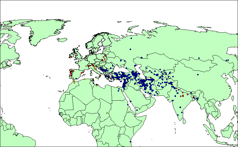
Funduks/fondacos/residential loggias, hospices/inns, and caravanserais/khans (code RHSE = resthouses) in Eurasia and Northern Africa c. 500 BCE-2000 CE. |
| dc.creator.PersonalName |
T. Matthew Ciolek |
| dc.creator.PersonalName.Address |
RSPAS, The Australian National University, Canberra, Australia [tmciolek@ciolek.com] |
| dc.subject |
trade routes |
| dc.subject |
methodology |
| dc.subject |
historical data |
| dc.subject |
historical maps |
| dc.subject |
cultural databases |
| dc.description |
703 data points in MapInfo, Google Earth (KML), and CSV formats with details of names and location of the three main types of resthouses (i.e. funduks, hospices/inns, sarais) in Eurasia and Northern Africa. |
| dc.publisher |
www.ciolek.com |
| dc.publisher.address |
Canberra, Australia |
| dc.date |
2006-10-10 |
| dc.type |
Data set |
| dc.format |
WWW pages - static |
| dc.identifier |
http://www.ciolek.com/OWTRAD/DATA/tmc-nodes-RHSE.html |
| dc.relation.type |
IsBasedOn |
| dc.relation.identifier |
A large number of printed and online sources. They are listed in: Ciolek, T. Matthew. 2004-present. A Catalogue of Georeferenced Caravanserais/Khans. Old World Traditional Trade Routes (OWTRAD) Project. Canberra: www.ciolek.com - Asia Pacific Research Online. Version 5.0 (Nov 2006). www.ciolek.com/OWTRAD/caravanserais-catalogue-00.html, as well as they are additionally referenced in the 'SCR' field of each record.
For discussion of functions served by these resthouses, and related terminology, and see: Ciolek, T. Matthew. 2006-present. A Glossary of Architectural, Geographical, and Historical Terms Relating to Long Distance Trade, Communication, and Pilgrimage Routes. Old World Traditional Trade Routes (OWTRAD) Project. Canberra: www.ciolek.com - Asia Pacific Research Online. Version 1.0 (Nov 2006).
www.ciolek.com/OWTRAD/trade-routes-glossary.html
|
| dc.relation.type |
IsGeoReferencedBy |
| dc.relation.identifier |
www.fallingrain.com: www.fallingrain.com/world/ |
| dc.relation.identifier |
www.satelliteviews.net: www.satelliteviews.net |
| dc.relation.identifier |
TGN: shiva.pub.getty.edu/tgn_browser/ |
| dc.relation.identifier |
ADL: fat-albert.alexandria.ucsb.edu:8827/gazetteer/ |
| dc.relation.identifier |
OWT: http://www.ciolek.com/owtrad.html |
| dc.language |
en - English |
| dc.coverage.x.min |
-20.00 |
| dc.coverage.x.max |
130.00 |
| dc.coverage.y.min |
00.00 |
| dc.coverage.y.max |
65.00 |
| dc.coverage.t.early |
-500 |
| dc.coverage.t.late |
2000 |
| dc.coverage.periodname |
Antiquity to 2000 CE |
| dc.coverage.placename |
Eurasia and Northern Africa |
| dc.coverage.spatial.resolution |
n/a (text-based information only) |
| dc.rights |
Copyright (c) 2006 - present by T. Matthew
Ciolek. Please direct comments, questions or
requests about OWTRAD license policy to tmciolek@ciolek.com |
| owtrad.notes |
Trustworthiness of the source: [v.high - high - moderate - low - v.low]: v.high
|
| owtrad.notes |
Geographic names follow the source's format |
| owtrad.notes |
Symbols and abbreviations follow the OWTRAD Notation |